Map Maker 5 course
Introduction
Maps are often used as a management tool. Regularly they are the outcome of an expensive and time consuming project,
… or …
they may lead up to valuable new projects.
If we fail to present our maps well the project may lose a costly punch. It is therefore wise to have, or be able to make, good quality maps.
This course is the product of many years of training. Ecologists, Farmers, Foresters, Hobbyists, Land Agents, Land Owners, Marine Biologists, NGO workers, teams in large organisations, and many more have followed this course with great success. They were all happy to use these skills at a basic functional level; some pressed on to do more complex GIS work.
This course has proven to be a game changer and a great asset for those who want to improve and bring wider scope to their businesses.
Photocopied paper maps drawn with fuzzy felt-tip-pen lines are a near thing of the past. Map making software has been the main tool for professionals for more than 40 years. This software has evolved from the first simple packages to the use of efficient, but complex, Geographic Information Systems (GIS). This course will establish a solid foundation for basic map making which can also lead to this more complex GIS work.
This course will take you through the steps to make the map as shown on the front cover: step-by-step, click here, click there. This course usually takes about 7 hours to establish a basic understanding what is involved and it will suggest a sensible workflow which can be applied in any map production, whatever map you would like to make.
Needless to say we need good software to do this. A brief software guide is given in our Mapping/GIS software review and explains why we use the software Map Maker 5.
Appreciating that not everyone may be using the software every day, the lay-out, index and annexes are such that this course can also be used as a quick reference guide once specifics are forgotten.
Enjoy the ride!
Latitude Cartography
WHY?
Clear lines
Drawing clear lines: that is what map making is all about.
A line divides, makes a distinction, sets borders and boundaries.
- A
- B
- Owned
- Not Owned
- x Ha = £ x
- xx Ha = £ xxx.-
- Arable Land
- Field Margin
- SS (Sitka Spruce)
- JL (Japanese Larch)
- Vague plans and ideas
- Concrete outlines and proposals
Lines,
clear lines.
Without those anything goes. With clear lines we all know where we are and what’s what.
One thing to consider:No matter how much time or money you spend on your project,
if you fail to present it well,
your client or target audience will not be impressed.
Clear lines.
It pays dividends to embrace good software and learn these basics well.
COURSE STRUCTURE AND INTENT
The Map Maker manual is like the manual of a car: it will show you where the spare wheel is, how to activate the AC and adjust the mirror: it will not teach you how to drive the car.
This course will do just that: it will teach you how to make maps.
The layout of this course
Different fonts are used. This font is used in introductions and for the ‘narrative’:
Every map tells a story, and so there is a narrative involved in making this map. In this course we want to build a dam and implement a hydroelectricity scheme. This has an impact on the landscape and requires careful planning. That’s the story which we will make up as we progress in making this map.
The aspects of this story might or might not apply in your day to day work, but the tools we will learn and procedures advised are the same in any map production. In fact the (fictitious) Base-map which we will use has been made with the same software applying the very same elements we will learn in this course.
When we refer to a particular menu, a tab, or specific setting in that menu we use a different blue font.
Images of the interface are annotated with arrows and numbers. Usually the image follows after the explanation.
For example:
(1) Click on the Help tab
(2) Click on the Video tutorials header
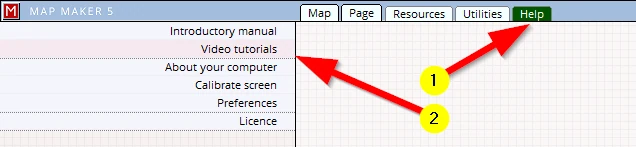
The chapters are grouped in ‘SESSIONS’ which might come in useful if you want to go through the course in stages.
This has turned out to be quite a long course: fret not, it is because of the excessive use of images which take up a lot of space. We reckon if you were to put your skates on, this course can be dealt with in about 7 hours, and under 2 hours if you are in a hurry… (see below…).
Key sections for when you are in a hurry
If you are in a hurry:
- read through chapters 1 to 3 – which cover the very basics in double speed.
- Then jump to chapter 11 to learn how a page layout is made and then
- learn in Chapter 15 how to save your map as a PDF or print it.
Although we follow a narrative and so it may seem we are jumping to and fro a bit and do things perhaps in odd ways, bear with it because hidden in all this are a lot of good, practical tips and valuable clues as to why some things are done in a particular way and at a particular moment. As mentioned, this sequence of events is typical in most map productions.
Some aspects are explained and repeated several times over, so you do not have to flip back too often trying to find where previous explanations were made.
Use this course as a reference
The content is such that this course can also be used as a reference. It could well be that only after many months you need to make another map and some basics are forgotten.
In such scenarios:
- read Appendix 1 and 2 first, then
- use the Contents index to find and read up on specifics.
Note: The map which we will make is using a Base-map which is situated in the UK. Map Maker 5 is developed in Scotland and thus the default map projection is that of the UK. For international users please refer to Appendix A5 ‘Setting up a map projection’ .
Note: The Map Maker 5 software is constantly being updated and expanded. Although every effort is being made to keep the images in this course up-to-date, don’t be alarmed when some images show tiny variations to the latest version of the software.